中文

Honeycomb maritime inspection application has developed a sound system, the use of our company's unmanned helicopter with camera can complete a variety of maritime work.
Maritime inspection requirements
Need to take off from the island, explore moving targets, endurance 1-2 hours, load capacity 10-15 kg, flight altitude 200m.
Learning about drone mounting forms and interface issues. According to the application requirements, the UAV needs to mount magnetic detection equipment, infrared equipment and visible light equipment, of which magnetic detection equipment and infrared equipment has selected products, but also need a set of visible light pod equipment. Magnetic detection equipment plans not to return detection signal, can remotely trigger the detection switch or ground directly after starting the flight, no need to record pos points, for the target ship and other specific targets for monitoring;
Technical support and flight services are required;
Magnetic detection equipment and airborne equipment have mutual magnetic interference problems, need further study, because of the oil-electric mixed magnetic interference is strong, it is recommended not to use oil-electric hybrid multi-rotor.
Solution
Data collection
Honeycomb UAV advantage
Fast response, mobility and flexibility
Drones usually fly at low altitudes, have easy airspace applications, and are less affected by climatic conditions and can fly under the clouds. Low requirements for landing sites (can be launched on board or ejected in situ), short preparation time, simple operation, convenient transportation.
A wide range of uses;
Honeycomb cover a variety of models of drones, there are vertical take-off and landing type, long-endurance type, long-range real-time mapping type, etc. , can be applied to unmanned aerial remote sensing mapping, real-time monitoring and other scenarios, applicable to oil-related fields. Complete a variety of tasks by carrying visible-light digital cameras, tilt cameras, multispectral cameras, high-definition cameras, infrared cameras, small photopods and other task loads.
Data acquisition is fast;
Compared with satellite and aerial remote sensing mapping systems, drones can quickly obtain Earth-to-ground image information in a short period of time, providing users with the results they need in a timely manner. Because the UAV has low-altitude flight capability, can fly under the clouds, the acquisition of aerial image resolution is high, good data quality.
The environment is adaptable and there is no safety risk to personnel
Drones are resistant to harsh environments, can operate at high altitudes and in hot weather, and can be as close as possible to various burst sites, transmitting back real-time data, and there is no risk of personnel safety.
Low maintenance costs and cost-effective use
One-time procurement investment is small, the general operating team does not exceed 4 people, after training can master the use, maintenance, post-treatment. Compared with satellites and manned aircraft, UAV systems are cost-effective to use and maintain on a daily basis.
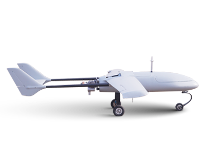
HC-530 VTOL Fixed wing UAV
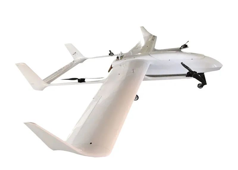
HC-530 is a high-performance UAV developed for special take-off and landing environment applications. The UAV system has high reliability and convenient handling and other excellent quality, while optimized pneumatic layout, equipped with fully automatic take-off and vertical landing system, can be equipped with high-precision stable photovoltaic platform, hyperspectral imager and full-frame digital camera and other task loads, with full autonomy, providing users with more convenient, more reliable control, more flexible use and more simplified training requirements for operators. After a series of flight, aerial testing and remote sensing tests, the HC-530 fixed-wing drone remote sensing system has been successfully applied in the fields of aerial photogrammetry, disaster monitoring and evaluation, emergency monitoring, forest fire prevention and urban fire protection, land and resources investigation, and has become another weapon of aviation remote sensing and monitoring.
HC-231 Unmanned helicopter
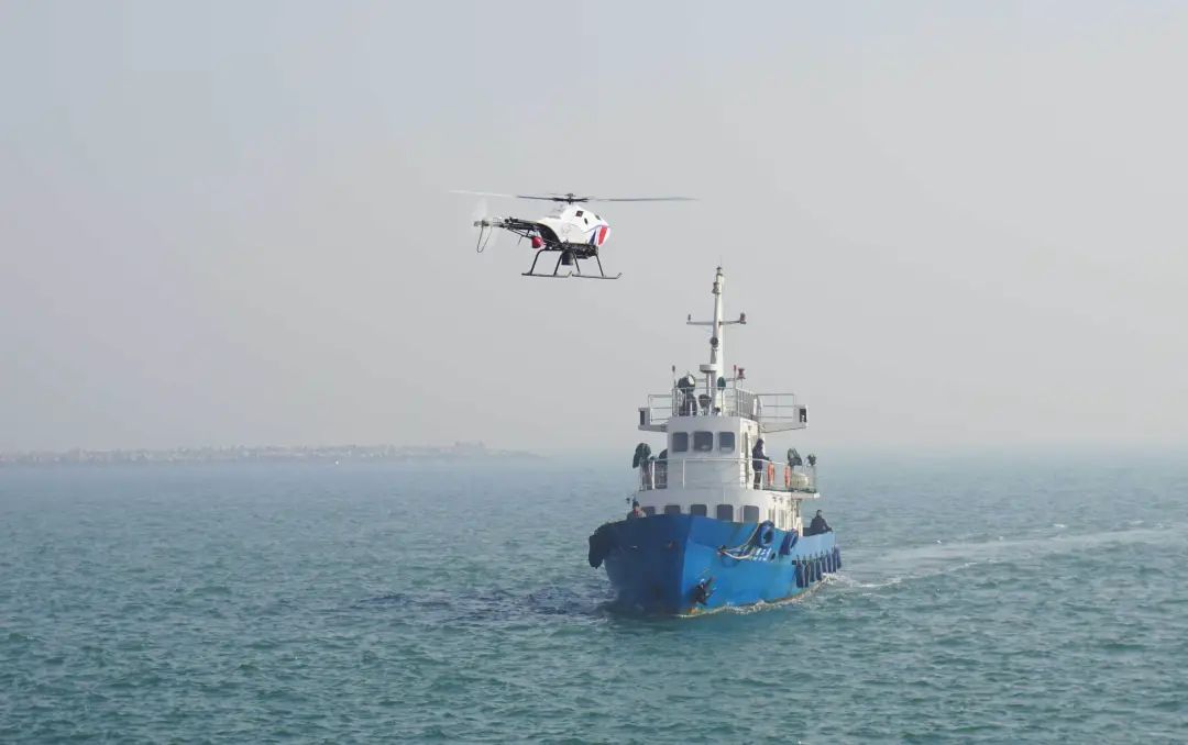
HC-231 unmanned helicopter is our company's independent design and development of products, with independent intellectual property rights, according to the special needs of user loads for the design of the fuselage. The helicopter uses a single rotor with tail oar pneumatic layout, the fuselage length of 3.2 meters, take-off weight of 120 kg, load 35 kg, flight time of 2 hours.
The HC-231 drone uses classic control technology for fully autonomous take-off and landing and track flight, position control, speed control and altitude control, and stable and reliable flight. The UAV platform can be equipped with aerial survey, airborne radar, spectroscopic measurement and other load equipment, ground control station can complete the helicopter data monitoring and load equipment control, HC-231 unmanned helicopter has been in the field of aerial survey, plant protection and military reconnaissance and surveillance has been better used.
The HC-231 unmanned helicopter platform is a core part of the unmanned helicopter system, and other systems are designed and configured around it. Unmanned helicopter body mainly includes: fuselage, rotor system, control system, transmission system, power system, tail, landing gear and other parts.

Scan the QR to Follow us on Wechat