中文
UAV technology is gradually coming into view. Drones are rapidly being used in a wide range of industries with their unique advantages. With the digitalization of highways and the gradual popularization of intelligence, "drones" are also showing more and more application prospects in the field of highways.
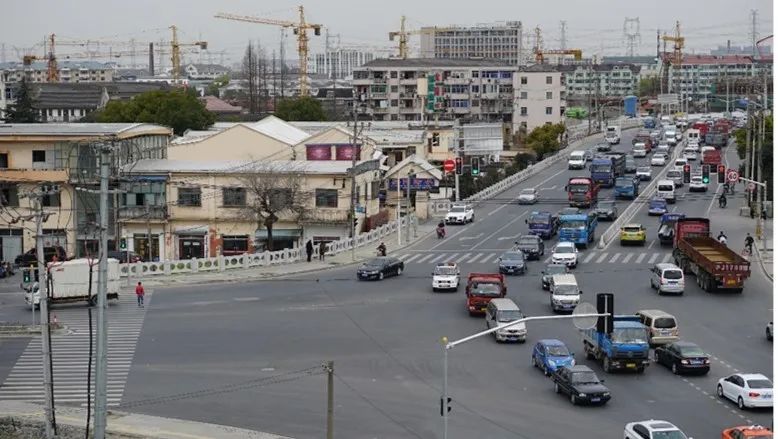
UAV can make up for the limited monitoring scope of fixed-point video surveillance system, can not track in real time shortcomings, for the rapid detection of important node traffic, optimize the police force configuration, play a positive role in promoting. High-speed traffic police through the drone high-altitude aerial photography to detect traffic changes in the jurisdiction and vehicle traffic at various toll stations to provide a basis for personnel configuration, blocking command, and road traffic; It can go to the accident site in a short time to monitor and collect evidence, and provide a reliable basis for dispatching rescue workers and equipment.

No.1 UAV request
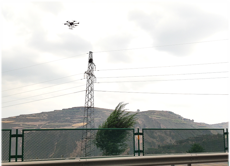
Drones are used in highway patrol enforcement
Aerial cameras patrol road conditions and broadcast the road conditions live. "UAV" flies high, can see far, especially in the face of holidays, or accidents, weather and other factors leading to road congestion on the highway, "UAV" equipped with high-definition camera equipment can be the first time to transmit the picture to the monitoring platform in real time, convenient for high-speed traffic police according to aerial shooting traffic conditions to deploy police force.
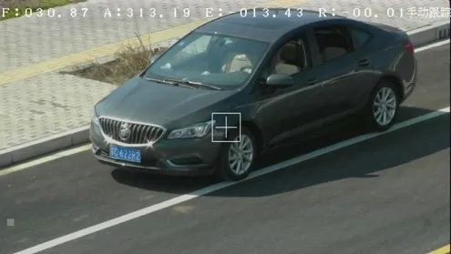
Drones" capture violations. The surveillance probe on the highway is fixed and does not effectively capture violations. The video and speed measurement equipment on the "drone" can fix all-round vehicle violations and effectively maintain the normal order of the highway.
Drones " are involved in highway patrols. At present, highway road patrol work, time-consuming and laborious. If we simultaneously control multiple "drones" through autonomous flight, multi-unit network and other ways of working, not only can quickly complete the highway road patrol tasks, but also to ensure 24-hour non-stop patrol video, greatly improve the efficiency of the road administration department
UAV inspection system
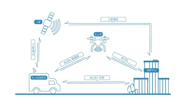
The UAV inspection system consists of command center management system, ground station system and monitoring UAV sub-system, data chain and communication system, mission load system.
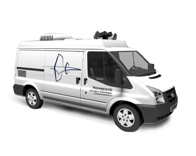
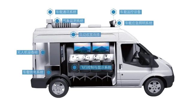
No.2 Command vehicle sub-system
The command vehicle may be equipped with the flight control and display system, remote link system, video conferencing system, on-board power supply lighting system, meteorological monitoring system, with UAV storage function, UAV control function, data transmission function, field wireless network coverage function, image access function, fiber optic access function, public wireless network access function, field power supply function, field lighting function, real-time weather monitoring function.

The vehicle can be equipped with operating stations, workstations and related power distribution equipment, with UPS to provide the use of vehicle power equipment, the station above the LCD screen, for aircraft route settings, flight data supervision and real-time data processing. The interior of the vehicle separates the equipment compartment from the working compartment and is equipped with air conditioning ventilation smoke alarm and other devices to greatly improve the comfort and safety of use.
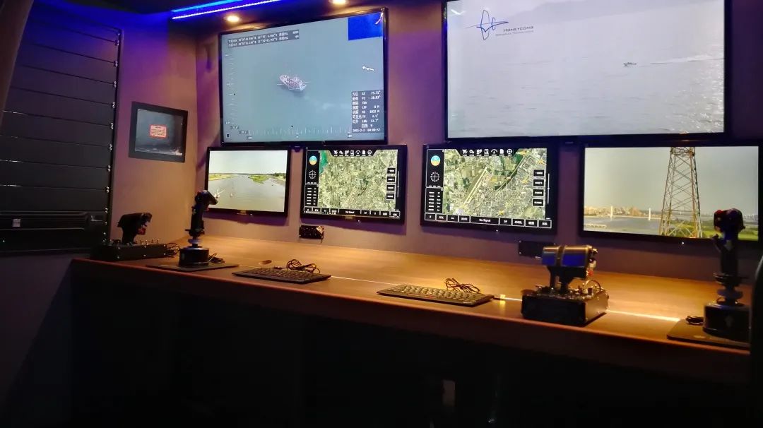
3.Flight control and display system
The station is equipped with multiple workstations, above the station is equipped with LCD screen, for aircraft route settings, flight data monitoring and real-time data processing, and equipped with drone joysticks for drone flight control.
Communication link system
1. Public network communication link system
Data transmission and communication through 4G network, with high bandwidth, wide coverage, multi-terminal access and multi-way video conferencing functions, with low cost, easy to use a wide range of advantages, but remote areas can not be covered, some emergency situations exist 4G network outages, limited scope of application.
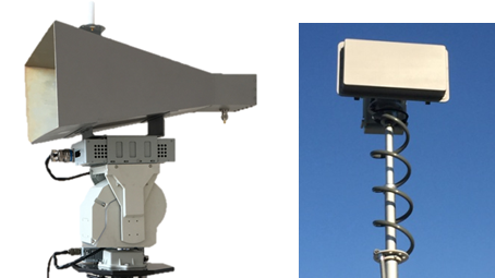
2. Data relay link system
Relaying through an on-board data link system, the drone monitoring data is relayed back to the command center through a relay control station or base station.
Relay measurement and control data chain, through the arrangement of a number of ground measurement and control stations along the line, the use of CDMA multi-access method to complete the seamless relay of upstream remote control data, downstream telemetry image broadcast distribution, to achieve a single point short-distance, multi-point relay network extension, so as to get rid of the measurement and control distance, obstacle blocking and other restrictions on the scope of task implementation, expand coverage areas, improve operational efficiency, especially suitable for power corridors, oil and gas pipelines, border patrol and other strip distribution network low altitude flight, long-distance inspection tasks At the same time, the rapid distribution and real-time sharing of monitoring data can be realized through the development of 4G wireless access equipment, which improves the efficiency of decision-making.
On-board powered lighting system
The car can be equipped with a generator, but also equipped with UPS power supply, to meet the needs of the car power equipment, the necessary battery charging.
Meteorological monitoring system
The vehicle can be equipped with meteorological stations to collect external environmental parameters, including: wind speed, wind direction, temperature, humidity, air pressure, altitude, rainfall, etc., to ensure the environmental adaptation and stability of the drone flight outside the cabin. The simple weather station rises and unfolds upon arrival at the designated location.
No.3 UAV Solution
| Solution | System components | Advantage |
| A | HC-332H +Dual camera+Payload | It is suitable for collecting evidence at the scene of accidents, and relieves traffic and illegal evidence on congested road sections |
| B | HC-521 +Dual camera+Payload | Suitable for long-term large-scale monitoring, fast flight speed, wide coverage, take-off and landing is not affected by the site |
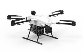
HC-332
Oil-electric hybrid six-rotor drone
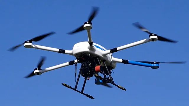
HC-332 hybrid UAV system is mainly for electric power, oil, agriculture and forestry, urban transportation, maritime, public security, fire protection and other industries, in the regional monitoring, road inspection, emergency relief, emergency command and other fields to meet the user's needs for the use of UAV systems. The system can be equipped with infrared camera, high-resolution camera and other photoelectric mission equipment, can be carried out over the target with continuous reconnaissance surveillance or fixed-point surround monitoring, especially can lock the ground target for circling gaze, record details. It can be operated in just two people, giving users unprecedented convenience.
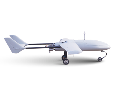
HC-521 VTOL UAV
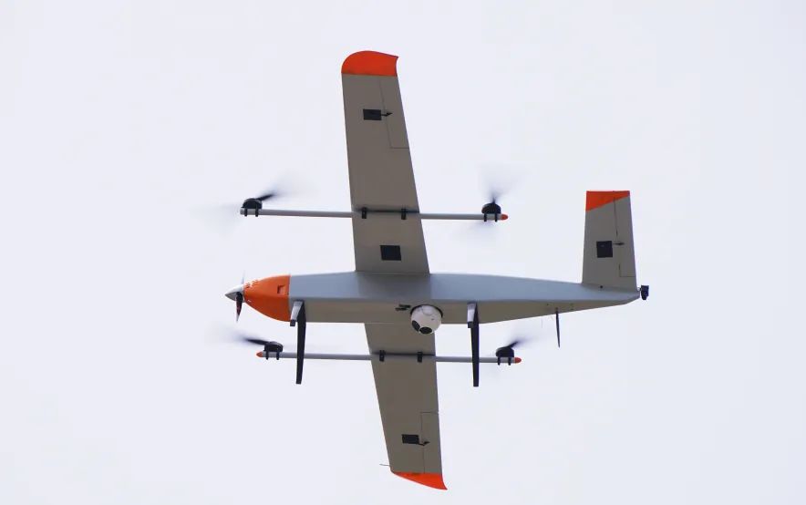
HC-521 vertical take-off and landing UAV system is mainly for power, oil, urban transportation, maritime, public security, fire protection and other industries, in the regional monitoring, road inspection, aerial photography, emergency relief, emergency command and other fields to meet the user's needs for the use of small-scale UAV systems. Due to the vertical take-off and landing method, the requirements for take-off sites are greatly reduced, while at the same time demonstrating the advantages of fixed-wing drones.
No.4 Telemetry and communication
Distributed measurement and control network
DL-X distributed over-the-horizon drone measurement and control network product is a large-scale deployment of networked drone data transmission system, supporting single or multiple drones in the distributed multi-point deployment of ground station signal coverage area over-the-horizon free roaming flight and station zero-time zero-drop frame seamless switching, can achieve real-time flight aerial video images and flight control data back (through the ground network) remote command center, and at the same time realize the command center to the drone real-time remote control. Can be used in large-scale UAV road patrol, long-distance power lines, oil and gas pipeline pipeline inspection, large-area forest fire monitoring and fire suppression, intelligent border patrol or large-scale UAV urban public security stability monitoring network.
4G-based real-time image transmission system
Airborne 4G image transmission system, through the nearby base station 4G network data transmission and communication, with high bandwidth, wide coverage, multi-terminal access and multi-way video conferencing functions, with low cost, easy to use a wide range of advantages, but remote areas can not be covered, data transmission is unstable, some high-altitude flight and emergency situations exist 4G network interruption, limited scope of application.
Mobile portable ground station GCS-D01
The drone ground monitoring station can integrate the digital radio reception module and the graph radio receiving module, which can monitor data and images in real time through the software interface, and the images, tracks and related parameters can be stored on the hard disk in real time.
No.5 Payload
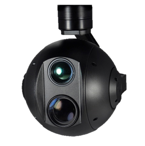
Cam-M10ZTir 10x zoom dual-optical photovoltaic pod with high-precision professional three-axis stabilization zoom pod, using high-precision encoder FOC control scheme, with high stability, small size, light weight, low power consumption characteristics. The camera is portable with 4 million effective pixels, 10x optical autofocus support, and HD 1080P recording. Internal two video streams, all the way 1080P30FPS local H.264 compression, stored in the device, the other way output 1080P60FPS format HDMI signal, used for wireless transmission, for aerial photography application characteristics, design. Fast focus, integrated function, compact size, support for PWM and serial control.
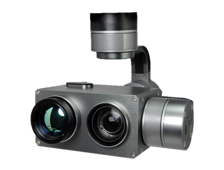
CAM-M10ZTir dual photoelectric pod
Cam-M30Tir 30x zoom dual photoelectric pod with high-precision professional three-axis stabilization zoom pod, using high-precision encoder FOC control scheme, with high stability, small size, light weight, low power consumption characteristics. The camera is available in 4 million effective pixels, supports 30x optical autofocus, and HD 1080P recording. Internal two video streams, all the way 1080P30FPS local H.264 compression, stored in the device, the other way output 1080P60FPS format HDMI signal, used for wireless transmission, for aerial photography application characteristics, design. Fast focus, integrated function, compact size, support for PWM and serial control.
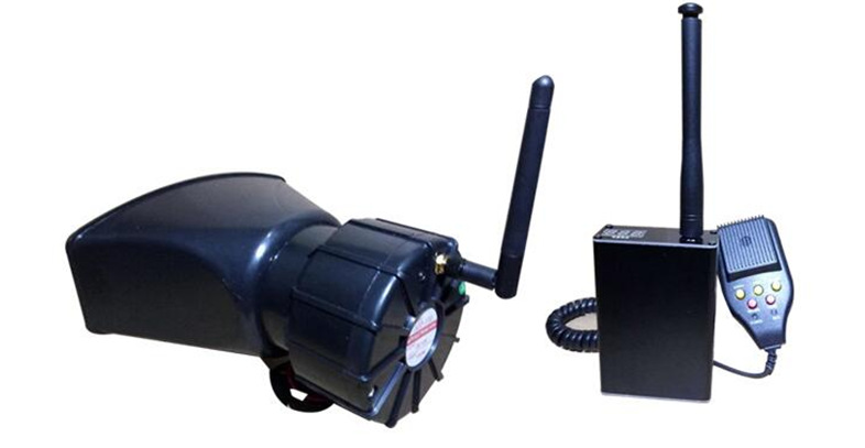
Drone equipped with wireless caller can be for the scene of real-time command, guidance personnel did not arrive when the unexpected situation, the product after strict channel encryption and magnetic shielding processing, stable performance, easy installation, module independent, with air shouting, warning tone and voice playback three functions, widely used in drone mounting.
No.6 Honeycomb UAV
Honeycomb for you to develop a detailed training plan, training is divided into theoretical training, practical training. Theoretical training is generally conducted at the supplier's location prior to the shipment of the product, and practical training is generally conducted at the user's location after the goods arrive at the buyer.
The list of information provided with the product includes: product specifications, maintenance instructions, certificates of product quality, packing lists and spare parts/accessories lists.
No.7 Real cases

Scan the QR to Follow us on Wechat